

 Return
hiking
Return
hiking
Pointe des Fours hiking trail
These "easiest 3,000s" bring the high-altitude mountain environment within reach. It's a real buzz being so high up: this experience of the high-altitude environment between Haute Maurienne and Haute Tarentaise gives you memories you'll treasure for a long time.
Description
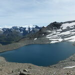
In places, the Vanoise is a rocky desert, where humans feel small, but it's here that the chamois feels right at home. And, when people feel small and lost, they build cairns. The one at Col des Fours is a real gem, standing an impressive two metres tall! It encourages you to extend your hike all the way to the lake, surpassing the 3,000 m altitude mark without too much effort. Chamois and ptarmigan might escort you some of the way. A 360° panoramic view of the border range with Italy and its eternal snows, just like those of the Vanoise (Grande Casse, Grande Motte, Mont-Pourri). The Grand Fond Lake, at the foot of the pass, reflects the pure sky, breathing life into the place, amid rocks whose colours range from gray to coppery brown. If you're craving some greenery, head down to the Fond des Fours refuge, nestled among the alpine meadows at the core of Vanoise National Park, where fearless marmots are ever ready to give you a warm welcome.
Additional welcome information
The duration of hiking trails is calculated using reference paces: 300 m/h ascent, 500 m/h descent and 4 km/h on the flat.
As hazards may occur at any time on the routes, the GPX tracks provided are not contractual. They are given for information only. Riders use them at their own risk, depending on their level of technological proficiency and their understanding of the terrain.
-
Minimum age: 10 years
Environments
-
 Mountain view
-
Mountain location
-
Close to GR footpath
-
In a nature reserve
Prices
Free access.
Itinerary
-
 Distance
6.2km
Distance
6.2km
-
 Itinerary type
Return
Itinerary type
Return
-
 Positive elevation gain
550m
Positive elevation gain
550m
-
 Negative elevation gain
550m
Negative elevation gain
550m
-
 Daily duration
03h00
Daily duration
03h00
-
 Marked itinerary
Yes
Marked itinerary
Yes
-
 Marking details
Vanoise National Park signposting (PNV)
Marking details
Vanoise National Park signposting (PNV)
-
Delicate passage
Some aerial passages to reach the summit. Take care when crossing a large névé in early summer. Appropriate equipment is essential.
-
 Nature of the terrain
Rock,
Stone,
Ground,
Not suitable for strollers
Nature of the terrain
Rock,
Stone,
Ground,
Not suitable for strollers
-
 Maximum altitude
3072m
Maximum altitude
3072m
Opening period
From 01/07 to 01/10 daily.
Subject to favorable snow and weather conditions.
Additional opening
-
Subject to favorable weather
-
Subject to snow conditions
Location
To get there by car: from Bonneval sur Arc, head for the Col de l'Iseran, and park in the Pont de la neige parking lot.
Documents

Animals
Animals accepted: No
Pets are not allowed on this hike in the Vanoise National Park.
Guidebook with maps/step-by-step
-
To guide you in the field, consult the "step-by-step" directional diagram provided in pdf.


-
Distance
6.2km
-
Daily duration
03h00
-
Positive elevation gain
550m
-
Negative elevation gain
550m